Secure, Compliant Aerial Systems for Critical Infrastructure & Government Operations

Spade Security delivers enterprise and NDAA-compliant aerial systems designed for perimeter security, infrastructure inspection, and rapid response operations. We configure, integrate, and deploy mission-ready drone platforms tailored to meet the operational and regulatory requirements of government, commercial, and critical infrastructure environments.

Government-Approved Drone Solutions

Enhance operational efficiency with Spade Security’s government-approved drone systems. Our Blue UAS–aligned and NDAA-compliant platforms meet strict federal security standards, delivering secure aerial surveillance, real-time situational awareness, and reliable performance for critical operations.

Drone ACSL Soten - Spade Security DroneNerds

ACSL SOTEN

ACSL’s SOTEN drone is designed for efficient and secure operations in challenging environments.

ACSL SOTEN is a compact, high-performance drone built for secure and efficient operations in challenging environments. Designed with advanced obstacle detection, a lightweight yet durable frame, and robust encryption protocols, SOTEN ensures reliable performance for critical missions. Whether for industrial inspections, public safety, or infrastructure monitoring, SOTEN delivers precision, security, and versatility in the field.

  • Max Flight Time:25 min (with standard camera, wind speed 17.9 mph)
  • Obstacle Avoidance Sensors: Vision system (Front, Top, Bottom), Infrared sensor
  • Ingress Protection: IP43
  • Operation Temperature: 32F to 104F
  • Number of Effective Pixels: 20 megapixels (Mechanical Shutter)
  • Video & Image Quality: 4K, 30fps

TAITEN SMART CONTROLLER

The ACSL TAITEN Smart Controller, the next-generation command center for your ACSL SOTEN drone. Featuring a bright 7-inch display and powered by a more advanced processor, TAITEN is fully integrated with the ACSL TAKEOFF ground control application to deliver superior precision and responsiveness.

Built tougher with an IP54-rated design, TAITEN stands up to the elements while offering enhanced usability with more customizable buttons. Dual-band 2.4 GHz and 5.8 GHz communications ensure reliable connections in demanding environments

Ascent AeroSystems Spirit

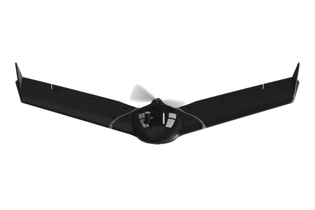
Spirit is a dependable, all-weather, high-performance unmanned aerial vehicle designed and built in the USA. Having joined the DIU Blue sUAS 2.0 Cleared list, Spirit offers an option for government customers to buy and operate without further technical review or approval. With impressive capabilities and a compact design, Spirit offers portability and efficiency. Check out the full specifications by downloading the official Ascent AeroSystems datasheet.
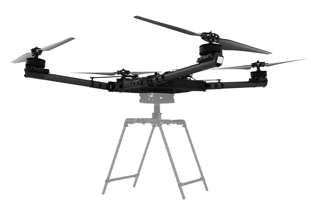
  • Coaxil Unmanned Aerial Vehicle

  • Max takeoff weight: 13.5 lbs (6.1 kg)

  • Max payload weight: 6.5 lbs (3 kg)

  • Compact & modular

  • Rugged & all-weather

Compact & Modular

Enterprise-level operations require solutions that are practical in the field. Spirit is compact and modular to support a growing ecosystem of easily swappable payloads and technology upgrades, so it’s easy to bring what’s needed, when it’s needed.

Rugged & All-Weather

Spirit’s rugged, all-weather airframe is protected against contamination so it can operate reliably in any weather, even heavy rain, sleet, snow and sand. Setup is quick and easy, allowing for takeoff from any type of terrain.

Efficient & High-Performance

With nearly 10 pounds available for batteries and payloads, Spirit sets the new standard for performance in its weight class. The highly streamlined airframe has a top speed of over 60 miles per hour and can operate in winds that would ground other UAVs.


Versatile & Adaptable

Spirit’s design allows for the integration of emerging technology and a growing ecosystem of payloads, power sources and launch methods that will support your mission today…and tomorrow.

 
Ascent AeroSystems Spirit - Spade Security DroneNerds
eBee TAC Public Safety - Spade Security DroneNerds

EagleNXT eBee TAC

The eBee TAC is a lightweight fixed-wing drone designed to fit snugly into a backpack and effortlessly operated by a single individual. Easily deployed in 3 minutes, it is a powerful drone solution for law enforcement, firefighters, and first responders.

Blue UAS approved, the eBee TAC is a trusted choice for public safety professionals seeking a dependable aerial solution. This certification attests to the drone’s adherence to rigorous safety standards, offering peace of mind to users as they tackle demanding missions with precision and confidence. eBee drones are also the only approved UAVs to fly Operations Over People (OOP) in the U.S.

  • 3-minute deployment
  • 90-min max flight time
  • Lightweight: 3.5 lbs
  • Up to 1,235 coverage at 400 ft
 

Extended Flight Time

With an extensive flight time of 90 minutes and an operational range of 55 kilometers or 34 miles with the eBee TAC Public Safety drone, the eBee TAC allows for efficient mapping of large areas, spanning up to 500 hectares or 1,235 acres.

Versatile Swappable Sensor Suite

Harnessing its versatile swappable sensor suite, the eBee TAC Public Safety facilitates real-time data collection, readily available for on-the-spot analysis and swift decision-making across key applications, including: search and rescue, firefighting, land management, disaster response, and surveillance missions.

3D, RGB, Multispectral & Thermal Cameras

eBee TAC Public Safety is compatible with a wide range of interchangeable photogrammetry cameras that capture reliable aerial imagery – from 3D models to orthomosaics – to suit every mapping job.

Lightweight Fixed-Wing Drone

Operate safely within more regulatory frameworks thanks to the eBee TAC’s light weight, which allows you to expand your range and operational possibilities. In addition, it has the best ratio energy/MTOW compared to heavier VTOL drones, offering better energy efficiency.

Remote ID

eBee TAC Public Safety has Remote ID identification system approved by the Federal Aviation Administration (FAA).

FREEFLY SYSTEMS DRONES - ALTA X

Drone technology has been taken to new heights with Freefly’s latest commercial drones, the Astro (NDAA/Blue), Astro Prime, and Astro Prime (NDAA/Blue).  Developed for applications in various industries like cinematography, inspection, and public safety, the Freefly Systems’ fleet delivers superior performance and unparalleled flight experience to commercial drone pilots. 

  • Up to 50-minute flight time (w/o payload)
  • Up to 30-minute flight time (w/ Phonix LiDAR)
  • Folds to half its normal size with the push of a finger
  • Fast & easy to deploy
  • Top speed of over 60mph (95km/h) & no assembly required
  • Customized for any aerial need


Enhanced Features

Alta X’s ActiveBlade design reduces vibration to 1/5th of the normal level. Reduced vibration means lower fatigue on components, longer motor bearing life, less payload vibration for cleaner data collection, and better footage when shooting.

Easy Mount Solution to a Variety of Payloads

LiDAR

Fly the best LiDAR Sensors available that were originally designed for full size helicopters for over 30 minutes.

Mapping Camera

Fly the 100 Megapixel Phase One camera for more than 25 minutes with Alta X and Mōvi Pro.

Mōvi Carbon

20-minute flight times and perfectly stable images at 240mm.

Mapping Camera

Fly 4K 1000FPS high speed Phantom Veo with seamless integration into Mōvi Pro.

LED

Fly cinema grade lighting for over 20 minutes with Alta X.
Ascent AeroSystems Spirit - Spade Security DroneNerds
eBee TAC Public Safety - Spade Security DroneNerds

Freefly’s Astro Prime - NDAA/BLUE

Astro Prime has all new 61-MP Sony LR1 payload, modular gimbal attachments, increased flight time, Doodle Labs 2.4 Ghz radio option, and enhanced security. It is Blue UAS listed and ready for work.

The new DIU Blue Framework enables customers to mix-n-match interoperable, NDAA compliant UAS components and software. The Framework provides advanced capabilities to sUAS developers and reduces risk for customers.

  • 37-Min Max Flight Time
  • 1500g Max Payload
  • 61MP Sony ILX-LR1 camera
  • Booms fold up to ½ the diameter
  • Powered vibration isolated payload mount (Smart Dovetail)
  • Astro Drone: NDAA and DIU approved


Optional Sensor Attachments

Freefly’s latest mini-gimbal with 61MP Sony LR1 has built-in mount points and USB hub to enable endless sensor attachments, allowing operators to configure their payload for the specific job that day!

  • 61-MP Sony LR1 Solo
  • 61-MP Sony LR1 + Thermal
  • 61-MP Sony LR1 + Laser Rangefinder

Swap Payloads in Seconds to Fit Your Mission

Mapping | Sony LR1

61 megapixel images for highly detailed mapping and inspection.

Thermal | Sony LR1 + Thermal

Thermal, zoom, and wide cameras to give insight from above.

LIDAR | Emesent Hovermap

LiDAR + Autonomy for the harshest, GPS denied situations.

SUNFLOWER LABS DRONE

Sunflower Labs delivers a fully automated security drone platform designed for perimeter protection and rapid incident response. Integrated with ground-based motion sensors, the system autonomously launches, investigates disturbances, and provides live aerial video to security teams — enhancing visibility, reducing response time, and strengthening site security without manual deployment.

Weight1.56 kg (battery included)
GPSMulti-band multi-constellation RTK
Body size28 × 28 × 21 cm
Full size (including prop guards)48 × 48 × 21 cm (57 cm diagonal)
Camera field-of-view50°(v), 100°(h)
Propeller size22.9 cm
Sensor resolution1920×1080 HD @25fps
Cruise speed14.5 km/h or 4 m/s
Bandwidth requirement3 Mbps (up & down)
Operational flight time15 min (+5 min safety reserve)
Video latency~250 ms
Battery capacity4000 mAh
Wind speed resistance9m/s, 32kph, 20mph
Obstacle avoidance range6 meters
Gust resistance14m/s, 50kph, 32mph
Max transmission distance600 meter radius
Operational temperatures-10°C to 40°C
Hover accuracy30 cm
Recharge time ratio1:2 flight time to recharge time (2 min flight = 4 min recharge)
Spade Drones
Weight35 kg
Runtime on backup battery1 hour
Dimensions when closed86 x 80 x 80 cm
ConnectivityEthernet + optional LTE modem
Dimensions when opening98 x 80 x 63 cm
Operational temperatures-20°C to +50°C
Power supply110V or 220V AC

GEOCADE AIRSPACE

Flights operate in geocaged airspace, ensuring the Bee stays strictly within your property.

FLIGHT OPTIMIZATION

Flights are optimized to focus only on what’s inside your property.

REAL-TIME BLURRING

Anything beyond your property line is automatically blurred in both live feeds and recorded footage, protecting the privacy of neighbors and bystanders.

eBee TAC Public Safety - Spade Security DroneNerds

ANAFI UKR

The Parrot ANAFI UKR is a compact, mission-ready reconnaissance drone built for tactical and field operations. Equipped with a stabilized 4K HDR camera and up to 35x digital zoom, it delivers high-resolution aerial intelligence in a lightweight, rapidly deployable platform. Designed for durability and secure operations, the ANAFI UKR provides reliable situational awareness for defense, public safety, and critical infrastructure environments.

• Size folded: 245 x 160 x 116 mm (9.6 x 6.3 x 4.6”)
• Size unfolded: 350 x 665 x 116 mm (13.8 x 26.2 x 4.6”)
• Mass: 959 g (2.11 lb)
• Maximum take-off mass (MTOM): 1,450 g / 3.20 lb
• Maximum transmission range:
     – 5G*: range without limits
     – Wi-Fi*: 5 km / 3.1 mi
     – MARS Radio*: 15 km / 9.32 mi
     – LoRa: 20 km / 12.43 mi
• Maximum flight time
     – with a Standard Smart battery: 38 min at 6 m/s airspeed
     – with an XLR Smart battery: 70 min at 6.5 m/s airspeed
• Maximum flight distance
     – with a Standard Smart battery: 23 km (14.35 mi) at 10 m/s airspeed
     – with an XLR Smart battery: 40 km (24.85 mi) at 14 m/s airspeed
• Maximum horizontal airspeed: 17 m/s
• Maximum horizontal groundspeed: 12.6 m/s
• Maximum ascent speed: 8 m/s
• Maximum descent speed: 8 m/s
• Maximum wind resistance:
     – During flight: 15 m/s
     – During take-off and landing: 15 m/s
• Maximum propeller speed: 8,500 rpm
• Sound power level: 77 dBA
• Service ceiling: 5,000 m above MSL (Mean Sea Level)
• Operating temperature: -36 °C to +50 °C (-33 °F to +122 °F)
• No take-off temperature limitation if battery is maintained between -20 °C and +50 °C (-4 °F to +122 °F)
• IP53: rain and dust resistant
• No NFZ (No-Fly Zones) limitation
• Takes off from / lands in the hand of the operator
• Optical navigation for GNSS-denied flight
• Indoor flight
• MicroSD card slot
• Deployment time: < 2 min

Optical Navigation for GNSS-Denied Flight

ANAFI UKR constantly monitors the accuracy of GNSSüeiöcity and positpjng. Should the drone detect spoofing or jamhing, it automatically enables GNSS-denie countermeasures to ensure real-time repositipniåg and eventually precise RTH.

Jamming Resistant

MARS* , ANAFI UKR’s main radio link, was developed specifically
to withstand electronic warfare systems. It maintains a robust connection,
pre-emptively escaping frequencies before they become jammed.


The drone embeds a secondary radio link, based on LoRa** protocol,
for safe operation and RTH, in the event of loss of the primary signal.

Extended Autonomy

ANAFI UKR can stay airborne for 70 minutes and has a range of 40 kilometers
making it especially suitable for long-lasting tasks such as aerial intelligence collection,
emergency response, infrastructure inspections, and surveillance missions.

5G Connectivity & Guarantee

ANAFI UKR automatically switches from Wi-Fi(2) to 5G(3)
and vice versa, opting for the strongest link.


• Robust connection, even in environments cluttered with massive obstacles
• Seamless control of the drone in electromagnetic interference-rich environments
• Ability to conduct BVLOS missions
• 1080p 30 fps live streaming
BVLOS
Beyond Visual Line of Sight
Cloud
Server

More Than a Drone — A Fully Deployed Security System

Purchasing a drone platform is only the beginning. Spade Security delivers fully deployed aerial security systems — configured for autonomous patrol, AI-triggered detection, and real-time monitoring center response.

From site assessment to live incident coordination, we transform drone hardware into an intelligent, operational security asset.

Why Deploy Through Spade Security?

Spade Security is not just a reseller — we are a deployment and integration partner.

Security-first configuration

On-site deployment & testing

VMS & SOC integration

Secure network architecture guidance

Operator training & SOP development

Ongoing service & compliance updates

Operational Use Cases

Perimeter & Campus Patrol

Autonomous or scheduled aerial patrols provide continuous visibility across large campuses, industrial sites, and secured perimeters — reducing reliance on manual guard rounds while increasing real-time awareness.

Alarm Verification & Rapid Response

Deploy drones immediately after a triggered alarm to visually verify incidents in minutes. Reduce false dispatches, improve response accuracy, and provide live situational intelligence to security teams.

Critical Infrastructure Inspection

Safely inspect substations, pipelines, towers, bridges, and restricted facilities without shutting down operations. Capture high-resolution visual and thermal data for proactive maintenance and risk mitigation.

Construction Site Monitoring

Monitor project progress, secure equipment yards, and document site conditions from above. Improve oversight, reduce theft, and maintain clear visual records for reporting and compliance.

Utility & Energy Asset Inspection

Perform routine and emergency inspections of power lines, solar fields, wind turbines, and grid infrastructure with minimal downtime — improving safety while lowering operational risk.

Event & Temporary Site Security

Provide rapid-deployment aerial coverage for large events, festivals, or temporary work sites. Enhance crowd monitoring, perimeter control, and emergency coordination with live aerial visibility.

Still have questions?

Yes. Spade Security offers NDAA-compliant and Blue UAS–aligned drone platforms suitable for government, municipal, and critical infrastructure environments.

Spade Security delivers complete deployment solutions — including site assessment, system configuration, secure integration, training, and ongoing operational support.

Yes. Many of our platforms support autonomous patrol routes, AI-triggered launches, and automated flight missions based on predefined security protocols.

Live video and telemetry can be integrated into your existing monitoring center or managed through Spade’s command center for real-time threat verification and response coordination.

Drone systems are ideal for construction sites, warehouses, campuses, utilities, industrial facilities, energy assets, and large commercial properties.

No. Drone technology enhances human security teams by improving visibility, response speed, and coverage — while trained professionals make final decisions and coordinate action.

Deployment timelines vary by site complexity, but most projects — including configuration, integration, and training — are completed within a few weeks.

Yes. Spade Security offers flexible deployment models including full purchase, managed services, and Drone-as-a-Service (DaaS) options.

The First Step to Protection is being Informed. Join Us

Every day, families fall victim to crimes they never saw coming—not because they were careless, but because no one warned them in time. Don’t wait for danger to find you. Stay ahead with expert safety tips, real-world prevention strategies, and insights from professionals who understand how threats really work. We’re not here to scare you. We’re here to prepare you. Because your safety—and your family’s peace of mind—can’t wait.
SPADE Security Services was started with a vision to deliver advanced and sustainable security solutions while making a meaningful impact on the industry. Founded by Pranil Shankar, a Marine Corps veteran and a disabled veteran, the company embodies his deep sense of duty, discipline, and commitment to community safety.

Address

SPADE Security Services

6556 Lonetree Blvd #201,
Rocklin, CA 95765

(888) 772-3301

Mon -Fri: 9:00 am – 5:00 pm

Follow us:

Copyright © 2026 Spade Security Services. All Rights Reserved